The many faces of
A native Washingtonian's look at the reawakening of Mount St. Helens
![]()
![]()
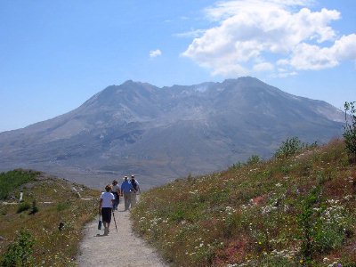
Geology field trips to Mount St Helens- 2005 and 2006
![]()
|
|
Current Eruption Activity For information on the current activity at Mount St Helens, you may find the following websites helpful: http://www.fs.fed.us/gpnf/recreation/current-conditions/special.shtml http://vulcan.wr.usgs.gov/News/framework.html http://vulcan.wr.usgs.gov/Volcanoes/MSH/Eruption04/
|
![]()
|
|
Welcome! You are visitor #1 million +
since June 10, 1998
On May 18th, 1980 the eruption of Mount St. Helens in southwest Washington state disrupted the lives of thousands and changed more than 200 square miles of rich forest into a grey, lifeless landscape. Now, more than twenty-six years later, the land around the mountain is slowly healing. Nature may be covering the scars of the 1980 eruption, but many people will never forget what happened that spring day.
![]()
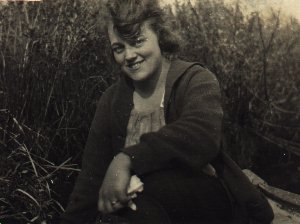
| I have always loved Mt. St. Helens. My mother's family helped settle the Silver Lake area just 25 miles west of the mountain. My great grandmother, Delpha Carnine Barstow, used to tell us stories about rowing across Silver Lake to get to and from school and spending summers with her brothers and sisters camping on the slopes of the mountain. In 1993, Grandma Delpha joined her husband Alva and many of our ancestors in the family cemetery on the shores of Silver Lake. Although I was only nine years old when Mountt St. Helens erupted, it was an important event in my life. It helped to shape who I've become. I now live within sight of the mountain and visit her as often as possible. |
Delpha Carnine Barstow in 1920, age 17. |
My love of the mountain has led to the creation of these pages. On this site you will find interesting facts and photos I have compiled about Mt. St. Helens before, during and after the eruption. She is a truly amazing lady and I hope you learn a little more about her during your visit here. If you are planning on visiting the mountain, make sure you stop by my Visitor's Guide and Related Links pages.
![]()
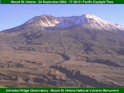
Want to see what Mt. St. Helens is doing right
now?
Check out the Live
VolcanoCam from Johnston Ridge
courtesy of Gifford Pinchot National Forest
![]()
Mount St Helens Fast Facts
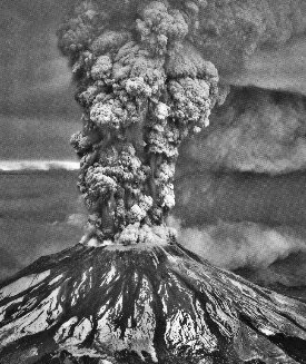
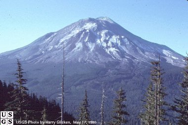
May 18, 1980 eruption photo by Austin Post
| Location of MSH | MSH, an active stratovolcano (or composite volcano), is located in southwest Washington State, USA (46.20 N by 122.18 W) approximately a 3 hour drive south from Seattle, Washington (90 miles) and a 2 and 1/2 hour drive north from Portland, Oregon (65 miles). |
| Date and Time of Eruption | May 18th, 1980, 8:32 am (PDT). Eruption was triggered by a 5.1 earthquake centered beneath the mountain. |
| Height of MSH (before & after) | MSH was 9,677 feet before the eruption and 8,363 feet after. 1,314 feet was removed by the May 18th eruption. |
| Debris Avalanche | The largest landslide in recorded history swept down the mountain at speeds of 70 to 150 miles per hour and buried the North Fork of the Toutle River under an average of 150 feet of debris. Some areas are covered by as much as 600 feet. In all, approximately 23 square miles of material was removed from the mountain. |
| Lateral Blast | The lateral blast swept out of the north side of MSH at 300 miles per hour creating a 230 square mile fan shaped area of devastation reaching a distance of 17 miles from the crater. With temperatures as high as 660 degrees F and the power of 24 megatons of thermal energy, it snapped 100 year old trees like toothpicks and stripped them of their bark. |
| Lahars (mudflows) | The snow on MSH that was not instantly flashed to steam by the heat, melted and formed large mudflows that destroyed 27 bridges, 200 homes, 185 miles of roadway, and 15 miles of railway. |
| Pyroclastic Flows | Pyroclastic flows rolled out of the crater for hours after the eruption. Covering 6 square miles, they sterilized the remaining soil with temperatures nearing 1,300 degrees F. |
| Ash | The massive ash cloud grew to 80,000 feet (18 kilometers) in 15 minutes and reached the east coast in 3 days. Although most of the ash fell within 300 miles of the mountain, finer ash circled the earth in 15 days and may continue to stay in the atmosphere for many years. |
| Number of Fatalities | 57 people were killed as a result of the eruption. Of these, 21 bodies were never recovered from the blast zone. |
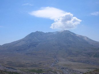
| Lava Domes Old and New |
The old lava dome rises 876 feet above the crater floor and is
about 3,500 feet in diameter. there have been no dome building eruptions
on this dome since
October 1986. If the dome were to re-establish the growth pattern it had in the
1980's, it would take 200 years to rebuild MSH to its pre-1980 size. The new lava dome (as of 2/1/2005) rises 1363 feet above the 1980 crater floor and is approximately 1500 feel long and 500 feet wide. It has been nicknamed the "whaleback" because of it's distinctive shape. |
| Damage Estimates | $1.1 billion for timber, civil works and agricultural losses. This does not include money for personal property losses, the cost of ash clean-up, or the loss of tourism in the area immediately after the eruption. |
| Animals | 7,000 big game animals, 12 million Chinook and Coho salmon, and millions of birds and small mammals are believed to have died in the eruption. |
| Benefits | Volcanoes provide us with geothermal energy, valuable minerals, fertile soil and recreational opportunities. |
| Current Monitoring | MSH can't even twitch without scientist knowing about it. Seismic disturbances, gas emissions, temperature, elevation changes (deformation), water levels, sediment flow rates, and even magma movement are all carefully monitored. |
| Future Behavior | MSH is expected to continue erupting but no one knows for how long. Pyroclastic flows, lahars, ejection of ash and pumice, and even the possibility of lava flows may all lie somewhere in MSH's future. |
![]()
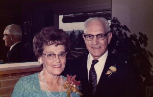 |
These pages are dedicated to the memory of my great grandparents, Alva Harry Barstow and Delpha Louise Carnine Barstow. They taught me so much about living and loving. I miss them both very much and I'm happy their mountain is watching over them. |
![]()
![]()
![]() Comments?
Suggestions? Questions? Write Me!!
Comments?
Suggestions? Questions? Write Me!! 
|
|
All text on these pages was written by Valerie Smith unless otherwise stated. While I encourage the use of my webpages as resources for school projects and papers, PLEASE do not plagiarize my work. |
Pages designed May 1998 by Valerie A. Smith. Please send all
questions, comments and suggestions to valerie@olywa.net
Thank you to the USGS and other featured photographers. Without the photos, these
pages would not be possible.
This page last updated
June 06, 2006.